
Tornado touches down in northern Wasatch Front
The National Weather Service confirmed a tornado touched down near a ridgeline west of Francis Peak in Fruit Heights on Friday, September 18, 2026.
Audio news · short story
~4 min · real voice narration
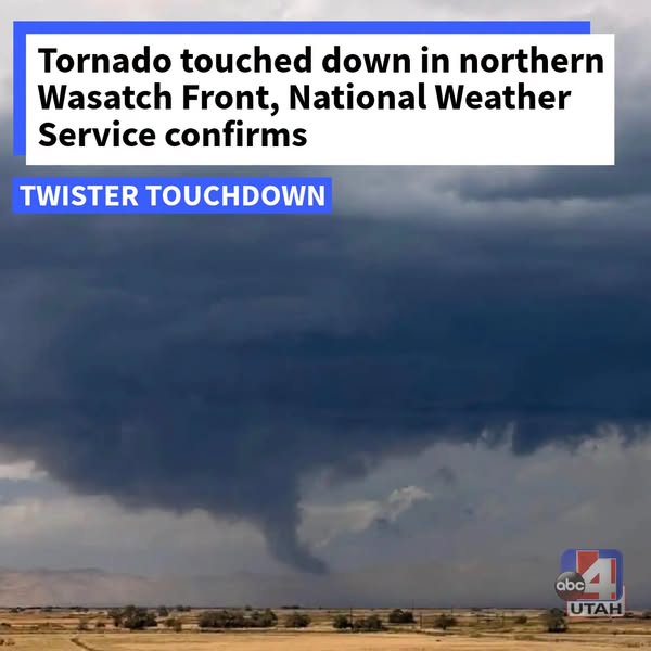
The National Weather Service confirmed a tornado touched down shortly before 2:00 p.m. on Friday, September 18, 2026. The touchdown occurred near a summit along the ridgeline extending west from Francis Peak in Fruit Heights, Utah. This meteorological event originated over the Great Salt Lake, gathering intensity as the system moved onshore into northern Davis County, where it exhibited significant rotation before making landfall near the ridgeline.
Meteorologists verified the touchdown by meticulously cross-referencing radar signatures with terrain maps and user-submitted video footage. By aligning the visual data from residents with known geographic markers along the Francis Peak ridgeline, the NWS confirmed the specific location of the touchdown.
Warning Status by County
| County | Warning Status |
|---|---|
| Weber | Warning Issued |
| Davis | Warning Issued |
| Morgan | Warning Issued |
Dynamics of the Storm System
The storm developed rapidly over the Great Salt Lake, a body of water that can influence local atmospheric patterns. As the system moved east, it gained enough structural integrity to produce a confirmed tornado before the circulation began to interact with the high terrain of the Wasatch Front. A local resident, who is a pilot, observed the storm from his porch, noting that the clouds were "completely occluded" by the time he returned with his camera, indicating the intensity of the rotation within the storm cell.
Many residents described the scale of the weather event as a "once-in-a-decade" occurrence for this particular part of Utah. The transition of the storm from a maritime-influenced system to a land-based tornadic event created a period of significant atmospheric instability across the three counties under the initial warning.
Observed Damage and Local Impact
The physical evidence of the storm’s path became apparent shortly after the wind and rain subsided. Damage reports across the region include uprooted trees and cracked fences, suggesting high-velocity wind gusts even outside the immediate path of the tornado. Several residents reported damage to their vehicles, specifically mentioning shattered side mirrors caused by debris or intense wind pressure.
Within the commercial sector, the impact was tangible. Water intrusion occurred at a Men’s Warehouse in Layton, highlighting how the accompanying torrential rain and hail overwhelmed exterior building defenses. Beyond wind damage, the hail was a significant hazard. Residents reported that the hail stones were large enough to cause physical welts upon impact, forcing many to seek shelter in the interior of their homes rather than observing the storm from outdoors.
Morgan County Emergency Management monitored the situation closely as the system moved through their jurisdiction. They observed that while the primary tornadic circulation weakened, the storm maintained its capacity to produce severe hail and heavy rain, causing lingering issues for local infrastructure and travel safety.
Warning Transitions and Verification
The NWS issued a tornado warning that covered Weber, Davis, and Morgan counties, keeping the alert in place until 2:15 p.m. As the system progressed, the agency shifted its operational status. For the communities of Layton, Kaysville, and Farmington, the NWS transitioned the tornado warning into a severe thunderstorm warning.
This transition highlights a distinction in the meteorological record: while the NWS confirmed the touchdown near the Fruit Heights ridgeline, they remained unable to verify whether a tornado actually touched down in the urbanized areas of Layton, Kaysville, and Farmington. In those locations, the damage and hazardous conditions were attributed to the broader severe thunderstorm, leaving the question of a secondary touchdown or a localized microburst unconfirmed.
NWS Safety Protocols Applied
During the active warning window, the National Weather Service reinforced standard safety protocols for residents in the path of the storm. The guidance prioritized immediate action to minimize risk from wind-borne debris.
- Primary Action: Move to a basement or an interior room on the lowest floor of a sturdy building.
- Secondary Action: Remain away from all windows to avoid injury from glass breakage or flying objects.
- Communication: Monitoring weather radio or local alerts until the warning was officially expired at 2:15 p.m.
These steps were critical given the reports of shattered vehicle mirrors and large, damaging hail, which posed a clear threat to anyone near unsecured glass.
Comparison with Tooele Event
This event follows a separate, distinct tornado that occurred in Tooele County on August 13, 2026. Comparing the two incidents provides context for the active late-summer season. The Tooele tornado was noted for its duration and path length, lasting approximately 14 minutes and carving a 4.3-mile path across the landscape.
The September 18 event near Francis Peak differed in its interaction with the local topography. While the Tooele tornado moved over more consistent terrain, the Wasatch Front event was characterized by its rapid development over the lake and its immediate contact with the ridgeline of the Wasatch range. These two events demonstrate the varied ways in which severe weather can manifest across Utah’s diverse geography, from the desert expanses of Tooele to the high-elevation slopes of Davis County.
Troubleshooting Storm Information
If you are attempting to verify reports from the September 18 event, consider the following nuances:
- 1Distinguish between warnings: Ensure you are checking if a specific location was under a tornado warning or a severe thunderstorm warning at the time of the event. The transition at 2:15 p.m. is the key dividing line for the Layton, Kaysville, and Farmington areas.
- 2Verify source credibility: The NWS relies on a combination of radar data and confirmed physical evidence. Personal accounts of "tornadoes" in areas where only severe thunderstorms were confirmed often arise from the visual intensity of "completely occluded" clouds, which can mimic the appearance of a funnel even without a ground touchdown.
- 3Understand localized damage: Much of the damage, such as water intrusion and cracked fences, can occur during severe thunderstorms with high wind and hail, even in the absence of a tornado. The NWS confirmation is specific to the Fruit Heights ridgeline, and attributing wider regional damage to the tornado itself should be done with caution unless confirmed by official surveys.
The September 18 incident serves as a reminder of the volatility of weather systems moving off the Great Salt Lake. The combination of wind, hail, and the confirmed touchdown near the mountain ridgeline underscores the importance of the NWS warning system in alerting residents to take cover in interior, low-level rooms. As the cleanup continues for those with damaged homes and vehicles, the record of this event remains a significant entry in the 2026 Utah weather archives, following just over a month after the Tooele tornado.
References
- 1Tornado touched down in northern Wasatch Front, officials confirm
- 2The National Weather Service has confirmed that a tornado touched ...
- 3'TWISTER TOUCHDOWN': Tornado touched down in northern Wasatch ...
- 4'I was getting pelted' Residents react after intense hailstorms, rain, and a ...
- 5The same night a rare tornado warning was issued for Tooele ...
- 6Carbon County residents assess damage after storms in the area
Frequently asked questions
›When and where did the tornado touch down?
The tornado touched down just before 2:00 p.m. on Friday, September 18, 2026, near a summit along the ridgeline extending west from Francis Peak in Fruit Heights.
›Did the tornado affect all counties under the warning?
The NWS confirmed the tornado touchdown near Fruit Heights; other areas remained under severe thunderstorm conditions.
›Which counties were under a tornado warning?
The National Weather Service issued a tornado warning for Weber, Davis, and Morgan counties.
›What kind of damage was reported?
Reported damage includes uprooted trees, cracked fences, shattered vehicle mirrors, and water intrusion into buildings, including a Men’s Warehouse in Layton.
›Is a tornado confirmed in Layton?
The NWS did not confirm a tornado touchdown in Layton, Kaysville, or Farmington; those areas were transitioned to a severe thunderstorm warning.
›Where did the storm develop?
The storm system developed over the Great Salt Lake and moved onshore in northern Davis County.
›When did the tornado warning expire?
The tornado warning expired at 2:15 p.m.
›How severe was the hail?
Residents reported intense hail, with some describing it as large enough to cause physical welts.
›When did the Tooele County tornado occur?
A separate tornado occurred in Tooele County on August 13, 2026.
›What are the recommended safety protocols during a tornado?
NWS protocols advise moving to a basement or an interior room on the lowest floor of a sturdy building and avoiding windows.
More in Trending


